Province de Kamphaeng Phet
Rédigé par Chang Aucun commentaire

Province de Kamphaeng Phet Province de Kamphaeng Phet La Province de Kamphaeng Phet se situe dans la région Nord de la Thaïlande. Cette province […]
Province de Kamphaeng Phet
La Province de Kamphaeng Phet se situe dans la région Nord de la Thaïlande. Cette province est subdivisée en 11 Amphoe
Kamphaeng Phet (Thai กำแพงเพชร) is one of the provinces (changwat) of Thailand, located in the north of the country. Neighboring provinces are (from north clockwise) Sukhothai, Phitsanulok, Phichit, Nakhon Sawan and Tak
Province de Kamphaeng Phet - Etymology
Le mot Kamphaeng signifie Mur, et le mot Phet provient de Sanskrit Vajra signifiant diamant (ou arme de Indra). De ce fait le nom de cette province siginifie litteralement Mur de Diamant...
The word Kamphaeng means Wall, and the word Phet from Sanskrit Vajra meaning diamond (or weapon of Indra). Hence the name of the province literally means Diamond Wall.
Province de Kamphaeng Phet - Geography
The main river of the province is the Ping, one of the sources of the Chao Phraya river. River flats make up much of the east of the province, while the west is mostly mountains covered with forests.
One of the most well-known products of the province is banana. Banana festivals take place in the province every year, to thank the gods for the harvest.
Province de Kamphaeng Phet - History
Kamphaeng Phet already was a royal city in the Sukhothai kingdom in the 14th century, then known under its old name Chakangrao. It formed an important part of the defence system of the kingdom, as well as later of the Ayutthaya kingdom.
Province de Kamphaeng Phet - Symbol
The provincial seal shows the city walls, as the city name means diamond wall. Provincial tree is Acasia catechu, provincial flower the Bullet Wood (Mimusops elengi).
Province de Kamphaeng Phet - Administrative divisions
The province is subdivided in 11 districts (amphoe). These are further subdivided into 78 subdistricts (tambon) and 823 villages (muban).
Mueang Kamphaeng Phet
Sai Ngam
Khlong Lan
Khanu Woralaksaburi
Khlong Khlung
Phran Kratai
Lan Krabue
Sai Thong Watthana
Pang Sila Thong
Bueng Samakkhi
Kosamphi Nakhon
Province de Kamphaeng Phet - Tourism
Sights
Kamphaeng Phet National Museum (พิพิธภัณฑสถานแห่งชาติกำแพงเพชร), located on Pindamri Road in Mueang district, houses ancient objects and other antique arts articles from various eras found in the provincial town. These include sculptured and earthen designs, heads of Buddha statues, traditional celadon products, sculptures of demons and celestial and human beings used to decorate Chedi bases or Vihans.
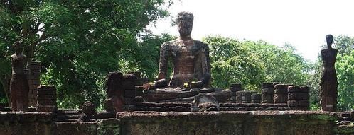
Kamphaeng Phet Historical Park is an archeological site in Kamphaeng Phet, Thailand. Along with Sukhothai Historical Park and Si Satchanalai historical park, it is a part of the UNESCO World Heritage Site Historic Town of Sukhothai and Associated Historic Towns. Major features in the Kamphaeng Phet Historical Park include archaeological remains of ancient sites such as Mueang Chakangrao to the east of the Ping River, Mueang Nakhon Chum to the west and Mueang Trai Trueng some 18 km from the town to the southwest.
Kamphaeng Phet Province Museum (พิพิธภัณฑสถานจังหวัดกำแพงเพชร เฉลิมพระเกียรติ) nearby is made up of groups of Central Region applied architectural style structures. There are exhibitions on the local history with replicas of the city, lifestyle and urban and hill tribal customs and traditions.
Mueang Nakhon Chum (เมืองนครชุม) is an ancient town on the west bank of the Ping River. Its 2-3 metre-high earthen walls run along the waterway. It is in this area that the famous religious tablets of Kamphaeng Phet have been discovered. Within the city walls are a couple of ancient sites such as the Kamphaeng Pom Thung Sethi (กำแพงป้อมทุ่งเศรษฐี) located on Phahonyothin Road just before entering the town. It is part of the laterite fortifications 83 metres long and 6 metres tall.
Wat Phra Borom That (วัดพระบรมธาตุ) is a temple situated in the centre of Mueang Nakhon Chum featuring a Burmese-style Chedi. To the south is an Ubosot housing several Sukhothai- and Ayutthaya-style bronze Buddha statues. The Chedi itself is believed to originally have been a Sukhothai-type structure, its style having been altered during a restoration work financed by a wealthy Burmese about a century ago. Another ancient town is Mueang Trai Trueng. It was built by King Chaisiri of Chiang Rai who fled invading enemy in 1542 B.E. (circa 999). Today most of the structures are in disrepair with only ruins of Chedis and ramparts. The town is about 18 km from Kamphaeng Phet on the Kamphaeng Phet-Khlong Lan road.
Talat Kluai Khai (ตลาดกล้วยไข่) is on the Kamphaeng Phet-Nakhon Sawan highway at Km.343. Scores of roadside stalls display and sell both raw and ripe Kluai Khai (a type of bananas).
Phra Ruang Hot Spring ( Bueng Sap) (บ่อน้ำพุร้อนพระร่วง (บึงสาบ) is located at Mu 3, Tambon Lan Dok Mai, 13 km from Kamphaeng Phet, 12 km on the left side off Highway No. 101. The 5 spots of hot spring naturally took place from under the ground. The temperature is approximately 50-65 °C. From a test of the Ministry of Public Health, there is neither contamination nor diseases, which are too harmful in accordance with the standard.
Khlong Lan National Park (อุทยานแห่งชาติคลองลาน) covers an area of some 300 km² over mountain ranges to the west of the province. The highest peak is about 1,400 metres. Of mainly virgin jungles, it is the source of several streams which flow into the Ping River. The park headquarters is near the Khlong Lan waterfall, about 60 km from town. Attractions within the park include the 95-metre high Khlong Lan Fall with scenic surroundings, and the Khlong Nam Lai Fall (น้ำตกคลองน้ำไหล), a 9-level cascade and located off Highway no.1117 at Km. 35 and 10 km further on). The Kaeng Ko Roi (แก่งเกาะร้อย) (off Highway No.1117 at Pong Nam Ron intersection) is a group of rock formations jutting out of the stream looking somewhat like all islands.
Mae Wong National Park (อุทยานแห่งชาติแม่วงก์) forms the border between Kamphaeng Phet and Nakhon Sawan and covers an area of about 894 square km. Most of the land is rich in various types of plants. Along the Khlong Lan -Umphang route passing through the park's area, which leads up to the mountains, are several viewing points between km 81 to 115. At Km. 102 is a beautiful road-side waterfall. Other falls within the park include the Mae Krasa (น้ำตกแม่กระสา), Mae Liwa (น้ำตกแม่ลีวา) and others.
Khlong Wang Chao National Park (อุทยานแห่งชาติคลองวังเจ้า) is located in King Amphoe Kosamphi Nakhon, 43 km from Kamphaeng Phet. This is an abundant forest with a density of naturally growing teak and beautiful waterfalls. Nearby the park, there is a hill tribe village.
Local Products
Kluai Khai (mini banana) is a famous produce of this province. Raw and ripe bananas as well as other local produces such as sticky paste (made of rice, bean, sesame and sugar) called Chachoengsao .
Ruins inside the Kamphaeng Phet Historical Park
Province de Kamphaeng Phet - Cartographie

Province de Kamphaeng Phet